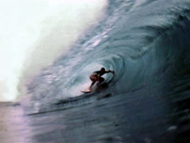
Monty Webber at G-Land, 1984.
G-Land is an internationally renowned surfbreak situated on the Bay of Grajagan, East Java, about half a day by road from the popular tourist destinations of Bali.
The surf break[]
The surf break at G-Land is generally described as three separate asses, which can link up to create a wave that peels for about 300m. These main sections are called Kongs, Moneytrees and Speedies. However, the layout of the surf break changes with the tide and different swell directions, creating additional sections. Most notable of these is The Cobra at Speedies.
Tourism[]
- Discovery
G-Land was first surfed in 1972 by Bob Laverty and Bill Boyum. Bob saw the break from the window of a flight he was on from Bali. When you see G-Land from this perspective, it is easy to see why Bob put together an expedition to find this amazing wave shortly after sighting it from the plane. Bill Boyum went along for the ride and they traveled from South Bali to G-Land on fat-wheeled Suzuki 80 motorcylces. The surf was great on their first trip. Three days of surfing bliss ended with sun-burnt eyeballs and the discovery of one of the planet's best lefts.
- Surf camp
Soon after the discovery, Bill and his brother Mike Boyum helped set up the first surf camp at G-Land, which was possibly the start of the surf camp concept that has since spread across the globe. Balinese surfer, Bobby Radiasa took over the operation in the late 70s and still runs it today. Bobby's Surf Camp has developed over the years into a resort offering various standards of accommodation and facilities to suit a range of holiday budgets.
Geomorphology[]
The south coast of Java faces the Indian Ocean, so it is exposed to large swells generated by low pressure systems circling Antarctica, many thousands of kilometers to the south. G-Land is situated on the eastern side of the Bay of Grajagan, so it has a westerly aspect; i.e. at rightangles to the predominant swell direction. As a result, swell wraps around the point and into the eastern side of the bay, producing long, walling left-handers, which peel at a rapid rate along a half kilometer stretch of shallow coral reef, forming perfectly hollow tubes that remain open the whole way.
G-Land is offshore between the months of April and September, which also happens to be when the swells are at their largest and most consistent. Since the swells are generated by low pressure systems circling Antarctica, their regularity coincides with the passage of these lows. So, the swell arrive in pulses, each lasting for a couple of days, with a couple of days between each swell.
It's best to plan a trip for the week following a full or new moon, since this is when the tide is high during the middle of the day, when the offshore wind blows strongest. Tide times are delayed about an hour each day, because the moon has advanced in its orbit (by 15 degrees) during the course of the day. So, if the tide is high at 9am on the day you arrive, by the end of the week, high tide will be at about 3pm. By contrast, the week before a full or new moon has low tides during the middle of the day. Since there are two weeks between full and new moons, high and low tide weeks alternate.
Tidal range increases when high tide is in the middle of the day, because the alignment of the Earth, Moon and Sun synchronises their gravitational affect on the tide. The highest tides occur every 7½ lunar months, when the alignment of the Earth, Moon and Sun coincides with the Moon's closest orbit. During extreme tides, the swell can surge at high tide but also back off when it is low. The tide drops more rapidly, reducing the surfable period of the day by as much as two hours. Alternatively, you could plan your trip to coincide with the moon's most remote orbit, which reduces tidal range by about a metre. Although this reduces the height of high tide, the benefit is that low tide doesn't drop so low and so the reef stays submerged for longer, which extends the surfable period of the day by a few hours.
Tsunami[]
Java is situated in a tectonic subduction zone, where the Indo-Australian Plate is moving northward, sliding under the Eurasian Plate at a rate of 67 mm/yr. Occasionally, however, the tectonic plate suddenly slips a much greater distance, resulting in an earthquake. In 1994, a major earthquake, registering 7.2 on the Richter Scale, occurred in the Java Trench, 205 km SW of G-Land. The quake triggered a tsunami, which swept through the surf camp about 40 minutes later [1]. The runup at G-Land was estimated to have been as high as 5.6 meters. No lives were lost at G-Land. However, 223 people perished further west, where the villages of Rajekwesi, Pancer and Lampon were almost completely levelled by the tsunami [2].
Surfer John Philbin was at G-Land on the night of the tsunami. He described hearing the surf and thinking it must be big. "But when the roar grew louder, I sat up inside my mosquito net, and just as I did, a churning wall of water blew through my hut." Richie Lovett described the experience as "being hit by a train at full speed". Richard Marsh initially thought a tiger was attacking them, but then realized it was a wave. Marsh and Lovett were swept hundreds of feet into the jungle by the wave. "I was completely panicking. It was a matter of surviving, just grabbing onto things to stay above the water, trying to keep all the debris away from my head and, above all, to get a breath." Marsh said. Lovett had to be returned to Australia for medical attention. "The hut had disappeared and I was entwined in logs and trees and bits of bamboo. When the water started to subside. I was stuck with my legs pinned under a whole lot of logs and rubbish."
The other surfers visiting G-Land when the tsunami struck were Monty Webber, Gerald Saunders, Rob Bain, Shanne Herring, Simon Law and Neal Purchase. (Please provide full list.)
Facts and figures documented by the Tsunami Survey Team.